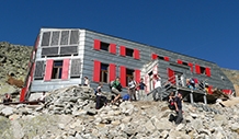
Mountain hut Žiarska chata


Mountain hut Žiarska chata (1325 m) had luck and was not smothered by an avalanche in 2009. The first hut was built before WW2.
Accommodation information
- Accommodation type: Mountain hut
- Zone: West Tatras
- Village place:
- Food: Half board
- Min. price: 15.00 €
- Capacity: 40


The hut was built in 1939 by the Slovakian tourist club. During the WW2 hut was burned down after that renovated. Because of the unsuitable conditions, the hut had to be demolished in 2006. The new hut was opened in the same year.
Rooms have a bathroom with WC. The hut is opened year-round.
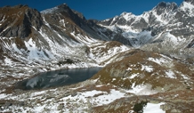
Position and range
- from Žiar blue trail (1:30)
- from Smutné sedlo (1:30)
- from Žiarské sedlo (1:30)
- from Baníkov over Jalovské sedlo (1:45)
Transport to the valley is possible by bus from Liptovský Mikuláš or by car.
Accessories building


Languages


Contact
Mountain hut Žiarska chata
Stanislav Poliak
TJ Družba Smrečany - Žiar
Website: http://www.ziarskachata.com/
e-mail: ziarskachata@gmail.com
telefon: +421 445 591 525
mobil: +421 917 598 721
GPS coordinates: (49°10'51.7216"N, 19°43'10.0911"E)